Earthquakes Near Me
- 4.7
- Rating
- 500.00K
- Installs
- Free
- Price
 Analysis by App-foxy
I like weather apps that tell me something useful without turning every screen into a wall of forecasts, and Earthquakes Near Me takes a very different route. This free Android app from SYNCREX focuses on worldwide earthquake activity, with a map designed to help me see where events happened and how far away they are from my location. It is not trying to replace a full daily weather service. Instead, it gives earthquake information its own dedicated space, which makes the experience easier to understand when seismic activity is the thing I want to check.
After spending time with it, my impression is that the app works best as a quick awareness tool. I can open it, look at recent activity, inspect the map, and put distant or nearby events into perspective. That sounds simple, but the distance view changes how I read earthquake information. A headline about an earthquake somewhere in the world can feel alarming until I understand its actual position relative to me. The app’s central idea is therefore practical: it turns a global event feed into something more personal.
What the free app actually offers
The cost is straightforward: the app is free to use. That matters because earthquake monitoring is the kind of utility many people may only open occasionally. I do not need to commit to a subscription or make a purchase simply to keep the app available for those moments when I want to check an event. Since the verified price is free, I judge its value by how useful that focused earthquake map is during ordinary checks, not by expecting the depth of a paid professional monitoring service.
You May Also Like

 Blood Strike: 2.5 Anniversary
Blood Strike’s Loadouts Turn Every Drop Into a Tactical Gamble
A close look at Blood Strike’s custom loadouts: how fast access to signature weapons reshapes its battle royale rhythm, rewards preparation, and narrows the gap between fights.

 Pandora - Music & Podcasts
Pandora’s Music Is Easy to Start, but Harder to Recover
Pandora’s strength is its low-effort path from a seed to a station. Its weak spot is how much confidence it asks you to place in connection, setup, and quiet recovery.

 8 Ball Pool
 Is Built on Rivalries, Rematches, and Routine
A close look at the rivalries, rematches, shared routines, and unanswered safety questions that turn a quick pool match into a persistent mobile community.

 Samsung Music
’s Quiet Strength Is Playing What You Already Own
Its reach comes less from spectacle than from dependable access to a personal library. That simplicity is both the app’s strongest retention engine and its ceiling.

 AccuWeather: Weather Radar
AccuWeather Review: A Quick, Clear Forecast for Everyday Decisions
For everyday plans, the best forecast is the one you can understand quickly. AccuWeather makes rain timing, radar, and local conditions easy to act on, with a few trade-offs.

 Hill Climb Racing
Why Hill Climb Racing Still Turns Crashes Into One More Run
A tiny car, a bumpy hill and one more upgrade: Hill Climb Racing keeps resurfacing because its simple chaos makes every near-miss feel personal.
More From Our News Desk



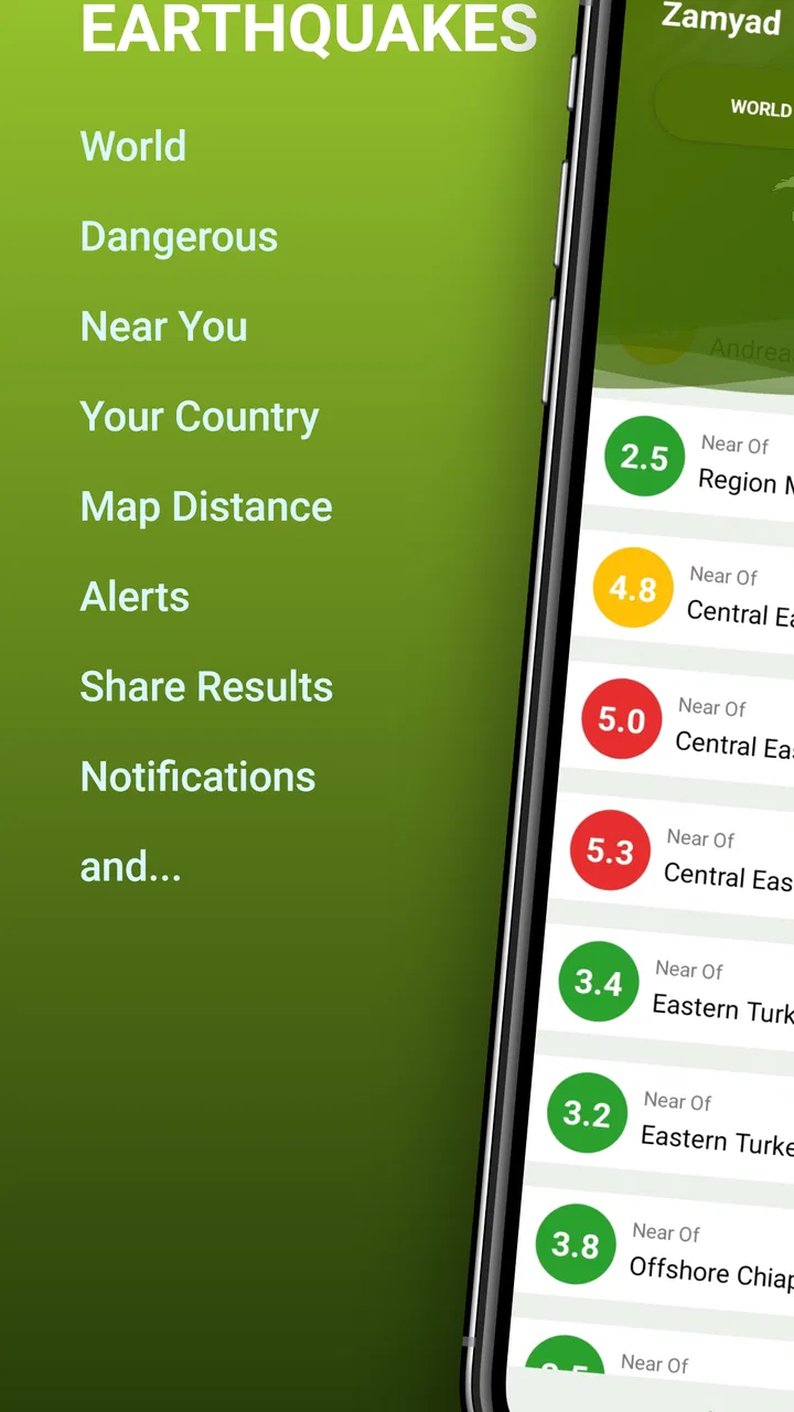
Its store summary describes worldwide earthquake tracking and an exact-distance view on the map. In practice, that gives the app a clear purpose rather than the broad, sometimes cluttered approach of general weather applications. A typical weather app may include an earthquake card among forecasts, alerts, radar, air quality, and other tools. Here, seismic activity is the main subject. That focus is the strongest reason to install it.
The app is rated for Everyone, so it is presented as suitable for a broad audience. It runs on Android devices using version 7.0 or later, which includes many older phones still used as secondary devices or household information screens. The current version is 4.108, and the app was released on March 5, 2023. Those details do not tell me how every phone will perform, but they do make it easier to decide whether an older Android device can be used for this particular purpose.
SYNCREX has built a focused tool rather than a general-purpose emergency suite. That distinction is important. I would not install it expecting a complete disaster-preparedness system, a replacement for official emergency communication, or a detailed scientific workstation. I would install it to answer a narrower question: what earthquakes are being shown, where are they, and how far away are they from me?
Reading the map without overreacting
The map is more useful than a simple list because it gives geographic context immediately. When I see an event marker, I can think about its relationship to coastlines, cities, and my own position instead of treating every entry as equally relevant. A worldwide feed can otherwise be noisy: earthquakes happen in many regions, and a long list may make the planet seem constantly unstable. The map helps separate global awareness from local concern.
One practical habit is to check the distance before reacting to the event label. If I hear about an earthquake through social media, I can open the app and use the map to see whether it is actually close enough to affect my situation. This is not a substitute for official instructions, but it is a useful first step for putting a report into geographic perspective. For relatives living in another country, the same workflow helps me check their region without searching through unrelated weather information.
Another useful approach is to use the app as a visual learning aid. Someone who is unfamiliar with earthquake-prone regions can gradually recognize where events tend to appear on a world map. That does not turn the app into a geology course, but the spatial view is more memorable than isolated place names. I find this especially helpful when comparing an event’s location with the places I travel to, the regions where family members live, or destinations I am monitoring before a trip.
A realistic everyday scenario
Imagine that I am at home in the evening and receive a message from a friend asking whether I felt an earthquake. Before guessing, I open the app and look at the map. If the nearest displayed event is far away, I have a sensible piece of context to share. If an event appears much closer, I know I should stop treating the app as casual reading and check local authorities, emergency notifications, and trusted safety guidance.
This workflow shows both the strength and the boundary of the product. The app can help me locate and assess an event’s apparent proximity, but it should not be the only source I use for urgent decisions. A map is informative; it is not automatically an evacuation instruction. I would keep official local alerts and emergency contacts available, particularly in an earthquake-prone area.
The same idea works before travel. If I am planning to visit a region where earthquake activity is a concern, I can use the global map to become familiar with the area and see how the app presents events there. I would not use it as a guarantee that a destination is safe, because a quiet screen cannot predict future activity. Its value is situational awareness, not prediction.
Where the value is strongest and where it stops
With over half a million installs and a 4.7 average from around twelve thousand ratings, the app has clearly attracted a substantial audience for this focused purpose. I treat those figures as signs that the basic concept is easy for many people to understand, not as proof that it will satisfy every user. The review count is in the hundreds, so I would still make my decision based on the workflow rather than assuming the rating answers every technical question.
The main value comes from concentration. A dedicated earthquake app reduces the steps between opening the phone and seeing seismic activity on a map. That can be more convenient than navigating through a large weather platform, especially for someone who checks earthquakes regularly or has family in several parts of the world. The exact-distance presentation is also more actionable than a bare location name because it connects a remote event to the user’s own position.
I also appreciate that the app is free for this kind of occasional use. If I only want to inspect earthquake activity after hearing a news report, a free tool is easier to justify than a paid service. I can keep it installed without feeling that I need to use it every day to recover a purchase. For students, travelers, families, and curious users, that low commitment is a meaningful part of the value.
At the same time, free access should not make me assume that the app covers every advanced need. The verified information establishes the price, category, developer, platform requirements, and core earthquake-tracking purpose, but it does not turn the application into a certified warning system. I would avoid making decisions based solely on any consumer app when official emergency channels are available. The right value judgment is therefore modest but positive: it is a convenient awareness layer, not a complete safety infrastructure.
The tradeoff between focus and depth
Compared with a usual weather app, this one is less useful for planning a normal day. It will not be my first choice when I want hourly rain forecasts, temperature trends, wind details, or a broad picture of tomorrow’s conditions. A general weather service wins whenever I need several environmental categories in one place. Installing this app makes sense only if earthquake information deserves its own shortcut on my phone.
Compared with a news app, it offers a more direct geographic view. News coverage may explain damage, local conditions, and human impact better, but it can be delayed, selective, or focused on the most dramatic events. A map gives me a faster way to inspect where an event is placed. The tradeoff is that the map may not provide the narrative context I need to understand what is happening on the ground.
Compared with official government or emergency services, the app is more convenient for browsing but should carry less authority in an emergency. Official sources are the better choice for evacuation orders, safety instructions, and region-specific warnings. I see Earthquakes Near Me as a companion for location awareness, not as the final word during a crisis.
There is also a psychological tradeoff. A worldwide earthquake map can encourage repeated checking, especially for people who already worry about seismic activity. The more often I refresh any event-based tool, the easier it becomes to confuse information with control. I would use it deliberately: check an event, understand its distance, then move on unless official guidance gives me a reason to keep monitoring.
How I would use it more intelligently
My first tip is to begin with geography rather than intensity or dramatic wording. I would identify the event’s position, compare it with my location, and then decide whether it is personally relevant. This prevents a distant global event from receiving the same emotional response as a nearby one.
My second tip is to pair the app with a simple emergency-information routine. Keep local authority channels, weather warnings, and family contact methods separate and easy to reach. When an earthquake is nearby, use this app to understand the map, then move to official guidance for action. That two-step workflow is safer than asking one consumer app to do everything.
My third tip is to use it for travel preparation without treating it as a forecast. Before visiting a new region, I can look at the map to understand its geographic context and then research local safety procedures elsewhere. The app helps me ask better questions, such as where the nearest event is shown and which local agencies provide instructions, but it cannot tell me that a future trip will be free from risk.
A fourth useful habit is to avoid interpreting a quiet map as proof that nothing can happen. Earthquake monitoring is about observing reported activity, while prediction is a different and much harder problem. The app’s value is strongest after an event has been reported or when I want a broad picture of activity. It is not a reason to abandon ordinary preparedness just because the screen looks calm.
Who will get the most from it?
I think the best audience is people who live in or travel through earthquake-prone regions, families with relatives abroad, and users who regularly follow international events. It is also a good fit for anyone who wants a dedicated map instead of a crowded all-in-one weather dashboard. Because it is free and supports Android 7.0 or later, it is easy to try on an older compatible phone without turning the decision into a major purchase.
Students and educators may also find the visual approach useful when discussing geography or natural hazards. The map encourages spatial thinking: an event is not just a name in a list, but a point in relation to other places. That makes the app more helpful for learning and conversation than a notification that provides no geographic frame.
I would be more cautious about recommending it to someone seeking guaranteed emergency alerts, professional seismic analysis, or detailed preparedness guidance. That person should prioritize official agencies and specialized resources. I would also suggest skipping it if earthquake information is not something the user expects to check. A general weather app may offer better everyday value for someone who mainly wants forecasts and only rarely thinks about seismic events.
For anxious users, the decision depends on habits. The app can reduce uncertainty by showing distance, but frequent checking might make worry worse. I would recommend installing it only if the user can treat it as an occasional information tool rather than a constant reassurance loop. Its focused design is helpful when used with boundaries.
My buy-or-skip verdict
There is no purchase decision here in the usual sense because the app is free. My recommendation is therefore based on whether its narrow purpose matches your routine. If you want a simple way to inspect worldwide earthquakes and understand their distance from you, I think it is worth trying. The map gives more context than a headline, and the dedicated focus is more convenient than digging through a broad weather application.
I would skip it if you need a complete weather service, a professional monitoring platform, or an authoritative emergency-warning system. Those are different jobs, and choosing this app for them would create unrealistic expectations. I would also skip it if you are unlikely to open an earthquake tracker, since a general weather app may serve your phone better with fewer separate tools.
For me, the strongest recommendation is conditional but clear: use Earthquakes Near Me for awareness, distance, and geographic context, not as your only emergency source. Its free access removes the main barrier to testing it, while its focused map makes it more useful than a generic event list for the right audience. SYNCREX has created a practical companion for checking seismic activity, and I would keep it installed when earthquake information is relevant to my home, travel, or family.
In the end, this is a small, purpose-built weather-category app rather than an all-purpose safety solution. Its appeal is precisely that it does one thing in a direct way. With over 500,000 installs and an Everyone age rating, it is approachable for a broad range of Android users, while the current 4.108 release keeps the product active enough to remain a realistic option for compatible devices. I would recommend giving it a try, then deciding whether its map earns a permanent place on your phone.
FAQs for Earthquakes Near Me
01What is Earthquakes Near Me, and what does it do?
Earthquakes Near Me is designed to help users monitor recent earthquake activity around the world, with a focus on events near their current location. After reviewing the app, its main value is the convenient presentation of earthquake information such as location, magnitude, depth, distance, and occurrence time. It is useful for staying informed, although it should be treated as an information tool rather than an official emergency-warning service.
02Does Earthquakes Near Me provide real-time earthquake alerts?
The app can display recently reported earthquakes and may offer notifications depending on its available settings, device permissions, and data source. However, users should not assume that every earthquake will trigger an instant alert. Reporting can be delayed, and notification coverage may vary by region. For urgent safety information, always rely on official government agencies, emergency services, and local warning systems.
03Does the app require location access to work?
Earthquakes Near Me can generally be used to browse earthquake activity without continuously sharing your location, but location permission may improve features that identify events close to you or calculate their distance from your device. During installation, review the permission request carefully. If you prefer greater privacy, you may deny access and use a manually selected location, where the app supports that option.
04Can I use Earthquakes Near Me while traveling or in another country?
Yes, the app is useful for checking seismic activity in different regions, making it suitable for travelers, international users, and people monitoring earthquakes near family or friends. Its map and event listings can help you explore activity beyond your immediate area. Keep in mind that data availability, alert speed, language support, and regional coverage may differ depending on the country.
05Is Earthquakes Near Me accurate enough for emergency decisions?
The app can be helpful for general awareness and for viewing earthquake details collected from external monitoring sources, but it should not be the only source used during an emergency. Initial magnitude and location estimates may change as agencies review the event. If you feel shaking or receive an official warning, follow local emergency instructions immediately rather than waiting for the app to update.
Pros
- Shows nearby earthquake activity with clear location and magnitude details.
- Provides timely alerts to help users stay informed about local seismic events.
- Simple interface makes recent earthquake data easy to browse and understand.
- Useful map view helps visualize the distance between you and reported quakes.
- Supports preparedness by keeping important seismic information readily available.
Cons
- Alert timing may vary depending on data sources and network connectivity.
- Minor tremors can generate frequent notifications that some users may find distracting.
- Coverage and accuracy may differ between countries or less monitored regions.
- Background location access can affect battery life and raise privacy concerns.
- The app cannot reliably predict earthquakes before they happen.

Earthquakes Near Me
Gallery